Search Term Record
Metadata
Name |
shoreline |
Number of Archive records |
0 |
Number of Library records |
0 |
Number of Photo records |
22 |
Number of Object records |
0 |
Related Records
-
2008.001.081 - Digital photograph
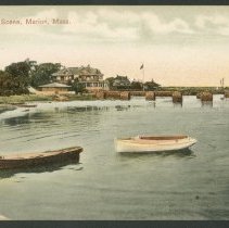
Shoreline - As a coastal town, Marion is viewed from its harbor nearly as often as it is seen from points of land. Intrepid postcard photographers over the years loaded their equipment into skiffs and rowboats and took to the water to capture views of the shoreline. The subjects often duplicated those already visited in other sections of this tour, so some sites may be familiar by now. But landward views from the water present opportunies for ...
Record Type: Photo
-
2008.001.082 - Digital photograph
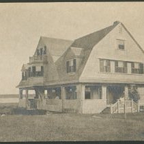
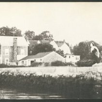
Shoreline - This Shingle-Style cottage, known as Hobbs House, stood on Lewis Street near Front Street, as seen in this view from 1908. Prior to 1953, Silvershell was a small, rocky, unimproved beach with only a crumbling wharf used by fishermen and intrepid swimmers. In 1953, the Town set out to improve the Silvershell area. Stone jetties were set along the northern and southern boundaries and truckloads of sand were brought in. In 1954, Hurrican...
Record Type: Photo
-
2008.001.083 - Digital photograph
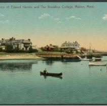
Shoreline - This view from Nye's Wharf about 1915 shows the west shore of Sippican Harbor, looking north. At the extreme left, 23 Water Street is partially visible. This was the summer home of Boston coal dealer Edward Hamlin, and later of Amory Houghton, who was to become U.S. Ambassador to France under President Eisenhower. Number 29 Water Street, to the right, was the residence of Daniel W. Knowlton. The float in the foreground is off 5 Water ...
Record Type: Photo
-
2008.001.084 - Digital photograph
Shoreline -This expansive view of Lewis Street residences as seen from the water about 1910 includes Hobbs House at left, which was later demolished in 1955 with the expansion of Silvershell Beach. The brick house at center, known locally as "Silver Shells," was owned at the time of this photo by industrialist Stanley McCormick, son of the inventor of the McCormick Harvester. In 1950, this property was purchased by James Cordon Gibbs, who had pre...
Record Type: Photo

-
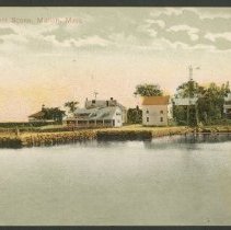
2008.001.085 - Digital photograph
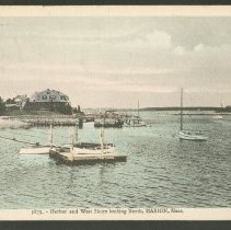
Shoreline - In this view, from about 1908, the beach house belonging to the H.R. Reed estate, out of view to the left across Water Street at Number 46, stands in the foreground. Behind it is the large J.C. Rhodes house at 57 Water Street, later owned by F.H. Bennett. In the distance are the Austin and Davis houses, with the Hotel Sippican Casino at the far right.
Record Type: Photo
-
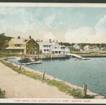
2008.001.086 - Digital photograph
Shoreline - A circa 1920 view of the foot of Main Street as seen from Long Wharf showing the yellow building now known as Zero Main Street. In the nineteenth century, it served as a meeting place for mariners setting out to sea, and the Universalist minister Rev. Theodore K. Toy/or often offered up a prayer there for the safety of the departing crews. The white building to the right was a sail loft, and as a private home it bears that name today.
Record Type: Photo
-
2008.001.087 - Digital photograph
Shoreline - A placid harbor scene from about 1903, looking from Island Wharf toward Bates Wharf and the outer harbor. The red-roofed, two-story structure at center was then a cooperage. The two windmills visible here were the primary sources of fresh water at that time. To the far left, the derricks of the stone barge shown in other views protrude above Sherman's Wharf (later Long Wharf). The gabled house to the right was the Dreyer Inn.
Record Type: Photo
-
2008.001.088 - Digital photograph
Shoreline - A waterside view of Bates Wharf, on a postcard mailed in 1923, with Long Wharf in the background. A substantial popple-stone structure has been erected on Bates Wharf by this time, and on Long Wharf a string of rude wooden shacks has been added to provide cover for shellfish shucking. The cupola of the Casino can be seen just to the right of the roof peak of the building on Bates Wharf.
Record Type: Photo
-
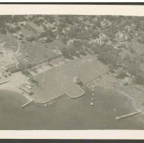
2008.001.089 - Digital photograph
Shoreline - An aerial view of Island Wharf Park about 1950. The octagonal bandstand was severely damaged by Hurricane Carol in 1954. It was demolished and a new structure with a sound-reflecting bandshell design was erected in its place. The inclusive cost of $5,131 was borne almost entirely by funds from the state's hurricane fund. The town paid only $175 of the project, and the new bandstand was completed in time for the July 4,1955 concert. ...
Record Type: Photo
-
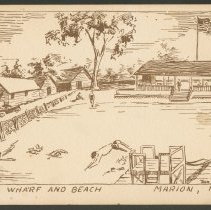
2008.001.090 - Digital photograph
Shoreline - Artist Don Jason created this loose rendition of a scene at Town Beach in the late 1940s. He also drew postcard views of Tabor Academy's Lillard Hall and the fireplace of the Old Stone Studio during the same era.
Record Type: Photo
-
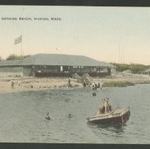
2008.001.091 - Digital photograph
Shoreline - The public bathing beach at Town Beach, sometime in the 1920s. Several swimmers in modest bathing costumes of the period are enjoying the cooling waters, while others relax in the shade of the pavilion. To the right of the pavilion, the towers of the Marconi Wireless Station dominate the horizon. 2nd & 3rd digital photographs - more views of the bathing beach and pavilion.
Record Type: Photo
-
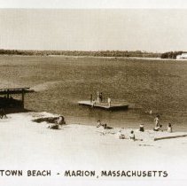
2008.001.092 - Digital photograph
Shoreline - In the 1940's, Marion's public bathing amenities were relatively sparse. This view shows the main beach to the nor of Island Wharf in the Village Center. At low tide, the near raft floated in water only waist deep, but the further raft was anchored deep enough for divingfrom the platform or taking the slide down. The only other public beaches were a tiny stretch of sand at Old Landing (now a boat ramp) and a small, rocky beach at Silv...
Record Type: Photo
-
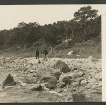
2008.001.093 - Digital photograph
Shoreline - The shoreline at Planting Island about 1907. At this time, Planting Island was a rugged, undeveloped area, abounding with heavy vegetation. The Sippican Indians had used it as a protected site for planting and grazing. By piling brush across the narrow neck by which it was reached, the Indians could discourage predators from raiding their foodstuffs. By 1926, the area was under development by the Planting Island Association, two paral...
Record Type: Photo
-
2008.001.094 - Digital photograph
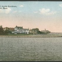
Shoreline - A waterside view of the Herbert Austin estate at 75 Water Street, about the 1970-20 era. The well-groomed stone seawall and expansive lawn behind it are where Miss Edith Austin befriended Canada geese that frequented the area. Behind the Austin house in the trees are the Hotel Sippican at left and its Casino to the right, both further north on opposite sides of Water Street.
Record Type: Photo
-
2008.001.095 - Digital photograph
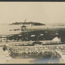
Shoreline - The gracefully curved seawall shown here created a level seaside garden for the Townsend / Davis Cottage near 81 Water Street. Beyond it is a walkway over the salt marsh to the Davis float. Beyond that spindly structure is the more substantial pier belonging to the Herbert Austin estate. In the distance across the mouth of the harbor are Little and Ram islands. The stone barge with derrick at right was a common fixture in the harbor a...
Record Type: Photo
-
2008.001.096 - Digital photograph
Shoreline - The figurehead from the bark Golden Sunset was brought to Marion by Edward Hamlin and mounted at the head of Bates Wharf, thus establishing a landmark visible from any number of vantages around the Inner Sippican Harbor. The Golden Sunset was built in England in 1876 and passed to French owners, back to the English, and finally to Norwegian owners, who converted her into a coal barge in 1920. 2nd digital photograph - right profile...
Record Type: Photo
-
2008.001.097 - Digital photograph
Shoreline -This is a later view of the Golden Sunset's figurehead on Bates Wharf, with the former cooperage, now fitted with a tall chimney, in the background. The wooden statue was carved by the workshop of Robert Bailes ofHendon, England. During the Hurricane of 1944, the figurehead became detached from her earlier vertical mounting and floated up into the inner harbor. She was recovered relatively undamaged-requiring only some restoration of h...
Record Type: Photo
-
2008.001.098 - Digital photograph
Shoreline - This real-photo view of Hathaway Wharf at Old Landing in the Upper Harbor was taken from the adjacent Delano Wharf, about 1950. Moorings at both of these humble wharves are acquired by application; the waiting list is several years long.
Record Type: Photo
-
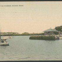
2008.001.099 - Digital photograph
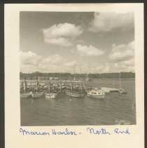
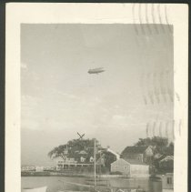
Shoreline - This real-photo view of Sippican Harbor taken from Island Wharf was mailed in 1947. At that time, the blimp base at South Weymouth, MA was still in operation, and sightings of blimps were common along the coastline.
Record Type: Photo
-
2008.001.100 - Digital photograph
Shoreline -This real-photo card mailed in 1977 shows the Admiral Harwood Cottage, 99 Water Street, at center (at this time identified as the Simmons Cottage), eventually to become the current home of the Beverly Yacht Club. At right center, Long Wharf extends out of the frame, and further up the shore Bates Wharf is visible. 2nd-4th digital photographs - additional views of the Beverly Yacht Club through the years
Record Type: Photo
